More recent
Your search returned 41 Results
-
Sort by : BND Publication
-
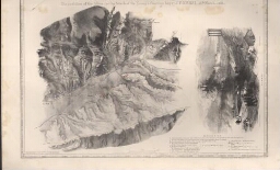
Affair of Sabugal
Affair of Sabugal
| Other title information | April 3rd. 1811 |
| Statement of responsability | surveyed and drawn by the Major T. L. Mitchell ; on zinc by C. Burton |
-
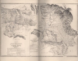
Movement against the french troops occupying the position of Guarda
Movement against the french troops occupying the position of Guarda
| Other title information | 29 th. March 1811 |
| Statement of responsability | surveyed and drawn by the Major T.L. Mitchell ; done on zinc by George Barnard |
-
Movements to dislodge the french army from its positions on the right bank of the Alba
Movements to dislodge the french army from its positions on the right bank of the Alba
| Other title information | 18 th. March 1811 |
| Statement of responsability | surveyed and drawn by the Major Pierrepoint ; finished by Major T.L. Mitchell |
-
Passage of the Ceira
Passage of the Ceira
| Other title information | 17 th. March 1811 |
| Statement of responsability | surveyed and drawn by the Major Pierrepoint ; finished by Major T.L. Mitchell |
-
Affair of the advanced guard of the allied army with the rear guard of the french army at Cazal Novo
Affair of the advanced guard of the allied army with the rear guard of the french army at Cazal Novo
| Other title information | 14 th. March 1811 |
| Statement of responsability | surveyed and drawn by the Major Pierrepoint ; finished by Major T.L. Mitchell |
-
Advance of the allies upon Condeixa
Advance of the allies upon Condeixa
| Other title information | 13 th. March 1811 |
| Statement of responsability | surveyed and drawn by the Major Pierrepoint ; finished by Major T.L. Mitchell ; on zinc by Erxleben |
-
Affair at Redinha
Affair at Redinha
| Other title information | 12 th. March 1811 |
| Statement of responsability | surveyed and drawn by the Major Pierrepoint ; finished by Major T.L. Mitchell ; on zinc by Erxleben |
-
Disposition of the allies for the attack of the enemy's position beyond Pombal
Disposition of the allies for the attack of the enemy's position beyond Pombal
| Other title information | 12 th. March 1811 |
| Statement of responsability | surveyed and drawn by the Major Pierrepoint ; finished by Major T.L. Mitchell ; on zinc by Erxleben |
-
Arrival of the advanced guard of the allies in presence of the french army near Pombal
Arrival of the advanced guard of the allies in presence of the french army near Pombal
| Other title information | 10 th. March 1811 |
| Statement of responsability | surveyed and drawn by the Major Pierrepoint ; finished by Major T.L. Mitchell ; on zinc by Erxleben |
-
The lines in front of Lisbon
The lines in front of Lisbon
| Other title information | with the redoubts, batteries, scarpments & military ways |
| Statement of responsability | surveyed by Major Sir T.L. Mitchell ; on zinc by H. C. Maguire |
-
Battle of Busaco
Battle of Busaco
| Other title information | general position of the french and alleed armies on the 26 Th. Sept.r 1810 |
| Statement of responsability | survey & drawing by Major Sir T.L. Mitchell ; on zinc by H. C. Maguire |
-
Movements of the two armies after the repulse of Marshal Massenas attack upon the position of Busaco
Movements of the two armies after the repulse of Marshal Massenas attack upon the position of Busaco
| Statement of responsability | survey & drawing by Major Sir T.L. Mitchell ; on zinc by A. R. Grive |
-
Position of Santarém, from a military survey ...
Position of Santarém, from a military survey ...
| Statement of responsability | by the Officers of Royal French Engineers ; engraved on stone by Fr. Hellringel |
-
Passage of the river Douro
Passage of the river Douro
| Other title information | on the 12 th. of May , 1809... |
| Statement of responsability | surveyed and drawing by Col.t Sturgeon ; draw on zinc by H.C. Maguire |
-
Sketch of the operations of the British Army in Portugal
Sketch of the operations of the British Army in Portugal
| Other title information | from the landing in Mondego Bay to the evacuation of Lisbon by the french |
| Statement of responsability | Pierrepoint |
-
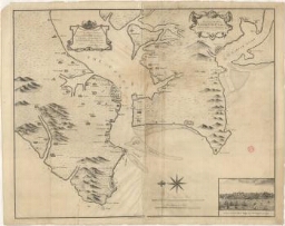
A plan and chart of Lisbon Setuval and its neighbouring country
A plan and chart of Lisbon Setuval and its neighbouring country
| Statement of responsability | To his Royal highness Henry Frederick Duke of Cumberland this plan is humbly inscribed by his Royal highness's most obliged and obedient servant Jospeh Smith Speer ; published as the Act dierects by Capt.n Speer |
| Publisher | Jospeh Smith Speer |
| Publication Date | June, 1773 |
-
Azores or Western isles
Azores or Western isles
| Statement of responsability | Surveyed by Capt. A. T. E. Vidal R. N 1843 e 4 ; sculpt. J. & C. Walker |
| Publication Date | 1867 |
-
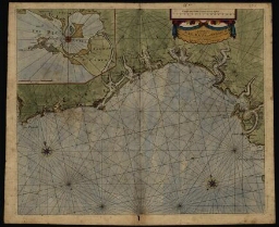
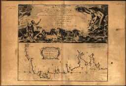
A chart of the Sea Coasts of Algrave [sic] and Andalusia between Cape St. Vincent and the Strait of ...
A chart of the Sea Coasts of Algrave [sic] and Andalusia between Cape St. Vincent and the Strait of ...
| Statement of responsability | sold by R. Mount at the postern on Great Tower Hill London |
| Publisher | R[ichard] Mount |
| Publication Date | [ca 1685] |
-
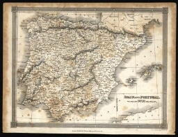
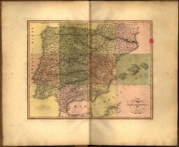
Spain and Portugal
Spain and Portugal
| Statement of responsability | published by T. Brown ; W. & D. Lizars |
| Publisher | T. Brown |
| Publication Date | [ca 1815] |
-
Spain & Portugal
Spain & Portugal
| Statement of responsability | by J. Arrowsmith |
| Publisher | J. Arrowsmith |
| Publication Date | 15 Feb. 1840 |
-
Spain & Portugal
Spain & Portugal
| Statement of responsability | by J. Arrowsmith |
| Publisher | J. Arrowsmith |
| Publication Date | 15 Feb. 1832 |
-
Spaind and Portugal, with their general divisions
Spaind and Portugal, with their general divisions
| Statement of responsability | by Samuel Dunn |
| Publisher | Laurie & Whittle |
| Publication Date | 1794 |
-
A new map of the kingdoms of Spain and Portugal with their principal divisions
A new map of the kingdoms of Spain and Portugal with their principal divisions
| Publisher | Robt. Sayer |
| Publication Date | 1790 |
-
Bowles's new pocket map of Portugal
Bowles's new pocket map of Portugal
| Statement of responsability | laid down according to the Sr. Nolin |
| Publisher | Carington Bowles |
| Publication Date | [ca 1780] |
-
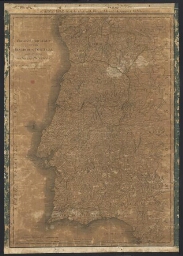
A new map of the kingdom of Portugal divided into its provinces
A new map of the kingdom of Portugal divided into its provinces
| Statement of responsability | by John Cary |
| Publisher | J. Cary |
| Publication Date | 1801 |
-
The kingdoms of Portugal and Algarve
The kingdoms of Portugal and Algarve
| Statement of responsability | J. Lodge |
| Publisher | Laurie & Whittle |
| Publication Date | 1794 |
-
The kingdoms of Portugal and Algarve
The kingdoms of Portugal and Algarve
| Statement of responsability | from Zannoniªs map by J. Lodge geographer |
| Publisher | Laurie & Whittle |
| Publication Date | 1808 |
-
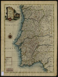
A new map of the kingdom of Portugal divided into its provinces
A new map of the kingdom of Portugal divided into its provinces
| Statement of responsability | From the latest authorities by John Cary engraver |
| Publisher | John Cary |
| Publication Date | Apr[il] 21, 1811 |
-
Chrographical map of the kingdom of Portugal divided into its grand provinces = Mappa corografica do...
Chrographical map of the kingdom of Portugal divided into its grand provinces = Mappa corografica do...
| Publisher | Ja s. Wyld |
| Publication Date | 1842 |
-
A chart of the coasts of Spain and Portugal with the Balearie Islands and part of the coast of Barba...
A chart of the coasts of Spain and Portugal with the Balearie Islands and part of the coast of Barba...
| Statement of responsability | by L. S. De La Rochete ; engraved and published as the Act directs by William Faden |
| Publisher | William Faden |
| Publication Date | August 30th 1779 |
-
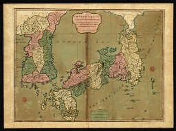
The empire of Japan divided into seven principal parts and subdivided into six kingdoms with the kin...
The empire of Japan divided into seven principal parts and subdivided into six kingdoms with the kin...
| Statement of responsability | from Kempfer and the Portuguese, printed by Laurie & Whittle |
| Publisher | Laurie & Whittle |
| Publication Date | 1794 |
-
The empire of China, with its principal divisions
The empire of China, with its principal divisions
| Statement of responsability | drawn from the surveys made by Jesuits, with improvements and additions from the maps of Mon[sieu]r DªAnville ; M. Bowen, Sculp[si]t |
| Publisher | Laurie & Whittle |
| Publication Date | 1794 |
-
Chorographical map of the kingdom of Portugal divided into its grand provincies = Mappa corografico ...
Chorographical map of the kingdom of Portugal divided into its grand provincies = Mappa corografico ...
| Statement of responsability | Published by W[illia]m Faden Geographer to the King and to H. R. H. the Prince of Wales |
| Publisher | W[illia]m Faden |
| Publication Date | 12 th August, 1797 |
-
Horta and Pim Bays; Fayal channel
Horta and Pim Bays; Fayal channel
| Other title information | Azores |
| Statement of responsability | surveyed by Capt[ai]n A.T.E. Vidal, R[oyal] N[avy] ; J. & C. Walker sculpt. |
| Publisher | Hydrographic Office |
| Publication Date | [ca 1864] |
-
Santa Maria and the Formigas
Santa Maria and the Formigas
| Other title information | Azores |
| Statement of responsability | surveyed by Capt[ai]n A.T.E. Vidal, R[oyal] N[avy] 1844 ; sculpt. J. & C. Walker |
| Publisher | Hydrographic Office |
| Publication Date | [ca 1873] |
-
San Miguel
San Miguel
| Other title information | Azores |
| Statement of responsability | surveyed by Capt[ai]n A.T.E. Vidal, R[oyal] N[avy] 1844 ; sculpt. J. & C. Walker |
| Publisher | Hydrographic Office |
| Publication Date | [ca 1850] |
-
Corvo and Flores
Corvo and Flores
| Other title information | Azores |
| Statement of responsability | surveyed by Capt[ai]n A.T.E. Vidal, R[oyal] N[avy] 1844 ; sculpt. J. & C. Walker |
| Publisher | Hydrographic Office |
| Publication Date | [ca 1850] |
-
Spain and Portugal
Spain and Portugal
| Statement of responsability | drawn & engraved by Alex. Findlay |
| Publisher | Thomas Kelly |
| Publication Date | [1835?] |
-
South America with its several divisions, according to the possessions of the european powers
South America with its several divisions, according to the possessions of the european powers
| Statement of responsability | by Thomas Kitchin, Hydrographer to His Magesty |
| Publisher | Laurie & Whittle |
| Publication Date | [post. Maio de 1794] |
-
New military map of Spain & Portugal, compiled from the Nautical Surveys of Don Vincent Tofiño, the ...
New military map of Spain & Portugal, compiled from the Nautical Surveys of Don Vincent Tofiño, the ...
| Statement of responsability | Vincent Tofino ; Thomas Lopez ; Neele sculp. |
| Publisher | J. Wallis |
| Publication Date | [post. 1812] |
-
A complete set of new charts on thirty-eight large plates containing an accurate survey of the coast...
A complete set of new charts on thirty-eight large plates containing an accurate survey of the coast...
| Statement of responsability | Giacomo Alagna of Messina |
| Publisher | J. Mount and Page |
| Publication Date | 1764 |