More recent
Your search returned 69 Results
-
Sort by : BND Publication
-
A new and exact map of Spain & Portugal
A new and exact map of Spain & Portugal
| Other title information | corrected according to the best observations |
| Statement of responsability | printed and sold by Thomas Jefferys Geographer |
| Publisher | Thomas Jefferys |
| Publication Date | 1717 |
-
Special war map of China, Corea, and Japan
Special war map of China, Corea, and Japan
| Other title information | compiled from the most recent and authentic sources |
| Statement of responsability | George Philip & Son |
| Publisher | George Philip & Son |
| Publication Date | [ca 1895] |
-
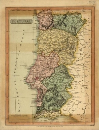
Portugal
Portugal
| Statement of responsability | Published under the superintendence of the Society for the Diffusion of Useful Knowledge ; Lapie, Lopez, Lemotte, Antillon ; J. & C. Walker sculpt. |
| Publisher | Baldwin & Gradock |
| Publication Date | Nov. 1st. 1831 |
-
Portugal
Portugal
| Statement of responsability | sculpt B. Smith |
| Publisher | C. Smith |
| Publication Date | Jan. 6th, 1808 |
-
Spain and Portugal
Spain and Portugal
| Statement of responsability | engraved by J. Wilson Lowry |
| Publisher | Chapman and Hall |
| Publication Date | 1847 |
-
A new map of France with the present seat of war
A new map of France with the present seat of war
| Statement of responsability | Published Feb.y 20th 1794 by J. Marshall |
| Publisher | J. Marshall |
| Publication Date | 1794 |
-
A new and correct map of the American islands, now called the West Indies, with the whole coast of t...
A new and correct map of the American islands, now called the West Indies, with the whole coast of t...
| Statement of responsability | by Tho. Kitchin |
| Publisher | The London Magazine |
| Publication Date | [1745] |
-
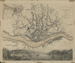
Oporto = Porto
Oporto = Porto
| Statement of responsability | Society for the Diffusion of Useful Knowledge ; Drawn by W.B. Clarke, archt. ; engraved by J. Henshall |
| Publisher | Chas. Knight & Co. |
| Publication Date | [1844?] |
-
Lisbon = Lisboa
Lisbon = Lisboa
| Statement of responsability | drawn by W. B. Clarke, Arch.t ; engraved & printed by J. Henshall ; published under the superintendence of the Society for the Diffusion of Useful Knowledge |
| Publisher | Baldwin & Cradock |
| Publication Date | 1833 |
-
Mogg's strangers guide to London exhibiting all the various alterations & imptovements complete to t...
Mogg's strangers guide to London exhibiting all the various alterations & imptovements complete to t...
| Publisher | Edward Mogg |
| Publication Date | 1847 |
-
A general mapp of the kingdom of Spaine
A general mapp of the kingdom of Spaine
| Statement of responsability | by Monsieur Sanson Geographer to the French King ; Francis Lamb sculp |
| Publisher | Guillaume Sanson |
| Publication Date | ca. 1680] |
-
Plan of the harbour of Holyhead, on which is represented the proposed extension of the Pier, and of ...
Plan of the harbour of Holyhead, on which is represented the proposed extension of the Pier, and of ...
| Statement of responsability | sculp. J. Basire ; Ordered, by the House of Commons, to be printed, 12 th June 1816 |
| Publisher | Luke and Hansard & Sons |
| Publication Date | 1816 |
-
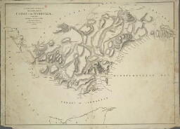
Map of the country round Cadiz comprehending St. Lucar de Barrameda, Xerez, Medina, Conil, Chiclana ...
Map of the country round Cadiz comprehending St. Lucar de Barrameda, Xerez, Medina, Conil, Chiclana ...
| Statement of responsability | from the Spanish Map of Jose Cardona Thomson sculpt. 14 Bury Str. Bloomsbury |
| Publisher | W. Faden |
| Publication Date | 1811 |
-
Oporto = Porto
Oporto = Porto
| Statement of responsability | Published under the Superintendence of the Society for the Diffusion of Usefull Knowledge ; Drawn by W. B. Clarck Archt. ; engraved by J. Henshall |
| Publisher | Baldwin & Cradock |
| Publication Date | 1833 |
-
África
África
| Statement of responsability | Engraved, printed and published by W & A. K. Johnston |
| Publisher | W. & A. K. Johnston |
| Publication Date | [ca 1862] |
-
Lisbon = Lisboa
Lisbon = Lisboa
| Statement of responsability | drawn by W. B. Clarke, Arch.t ; engraved & printed by J. Henshall ; published under the superintendence of the Society for the Diffusion of Useful Knowledge |
| Publisher | Charles Knight |
| Publication Date | [1844] |
-
Coast of China
Coast of China
| Publisher | A. Arrowsmith |
| Publication Date | [1832] |
-
A new chart of the coast of Brazil from cape St. Thomas to the port of Santos
A new chart of the coast of Brazil from cape St. Thomas to the port of Santos
| Statement of responsability | drawn from the best surveys by J. W. Norie Hidrographer & C |
| Publisher | J. W. Norie & Cº |
| Publication Date | 1834 |
-
Africa
Africa
| Other title information | with index |
| Statement of responsability | by William Shawe FRGS |
| Publisher | George Philips & Son |
| Publication Date | [1892] |
-
The Island of Madeira (Portuguese)
The Island of Madeira (Portuguese)
| Publisher | Edward Stanford |
| Publication Date | [ca 1880] |
-
Spain and Portugal
Spain and Portugal
| Publisher | The London Geographical Institute |
| Publication Date | [1912] |
-
A military sketch of the country between Lisbon and Vimiero occupied by the British Army under the c...
A military sketch of the country between Lisbon and Vimiero occupied by the British Army under the c...
| Statement of responsability | Published with permission of the Quarter Master General by James Wyld, geographer to his Magestaty |
| Publisher | James Wyld |
| Publication Date | 1827 |
-
Portugal including Algarve
Portugal including Algarve
| Statement of responsability | Published by Robert Wilkinson ; sculp. J. Froggett ; From the various provincial surveys corrected by the nautic observations Don Vicente Tofino and the topography of Don Tomaz Lopez |
| Publisher | Robert Wilkinson |
| Publication Date | Octr. 7th 1809 |
-
Benguella railway
Benguella railway
| Other title information | plan shewing railway from Lobito Bay to 750 kilometres |
| Statement of responsability | Douglas Fox & partners ; Robt. J. Cook & Hammond lithographers |
| Publisher | Robt. J. Cook & Hammond lithographers |
| Publication Date | [192?] |
-
Southern Africa including the Cape Colony, Natal, South African Republic, Orange Free State Bechuana...
Southern Africa including the Cape Colony, Natal, South African Republic, Orange Free State Bechuana...
| Other title information | with index |
| Statement of responsability | George Philip & Son |
| Publisher | G.P. |
| Publication Date | [ca 1898] |
-
O Douro portuguez e paiz adjacente contando do rio quanto se pode tornar navegavel em Espanha =
O Douro portuguez e paiz adjacente contando do rio quanto se pode tornar navegavel em Espanha =
| Statement of responsability | por Joseph James Forrester ; sculp. W. Hughes |
| Publisher | Joseph James Forrester |
| Publication Date | June 1st 1848 |
-
A new chart of the Azores, or western islands, Madeira, the Canary islands and part of the coasts of...
A new chart of the Azores, or western islands, Madeira, the Canary islands and part of the coasts of...
| Statement of responsability | by R. Holmes Laurie ; delint. John Purdy |
| Publisher | R. H. Laurie |
| Publication Date | 1821 |
-
A new chart of the Azores, or western islands, Madeira, the Canary islands, and part of the coasts o...
A new chart of the Azores, or western islands, Madeira, the Canary islands, and part of the coasts o...
| Statement of responsability | by R. Holmes Laurie, Charttseller to the admiralty, &c.&c ; John Purdy, Delint. |
| Publisher | R. H. Laurie |
| Publication Date | 1842 |
-
Lisbon = Lisboa
Lisbon = Lisboa
| Statement of responsability | drawn by W. B. Clarke, Arch.t ; engraved & printed by J. Henshall ; published under the superintendence of the Society for the Diffusion of Useful Knowledge |
| Publisher | Chapman and Hall |
| Publication Date | [1844] |
-
Chart of the Island of St. Michael
Chart of the Island of St. Michael
| Statement of responsability | by W. Harding Read ; grav. Stephenson |
| Publisher | William Heather |
| Publication Date | 1808 |
-
General map illustrative of the operations in Portugal, and the adjoining frontier of Spain
General map illustrative of the operations in Portugal, and the adjoining frontier of Spain
| Statement of responsability | James Wyld |
| Publisher | J. W. |
| Publication Date | [18--] |
-
A military sketch of the country between Cadiz and Marbella
A military sketch of the country between Cadiz and Marbella
| Statement of responsability | compiled from information collected by Captain Landman of the Royal Engineers and other oficers |
| Publisher | A. Arrowsmith |
| Publication Date | 1st. January 1811 |
-
Chorographical map of the Kingdom of Portugal, divided into its grand provinces = Mappa Corografica ...
Chorographical map of the Kingdom of Portugal, divided into its grand provinces = Mappa Corografica ...
| Statement of responsability | published by Ja[me]s Wyld (sucessor to Mr. Faden) Geographer to Her Majesty |
| Publisher | James Wyld |
| Publication Date | 1842 |
-
Spain and Portugal divided into their respective kingdoms and provinces, from the Spanish and Portug...
Spain and Portugal divided into their respective kingdoms and provinces, from the Spanish and Portug...
| Statement of responsability | published by W. Faden, Geographer to His Majesty and to H. R. H. the Prince of Wales |
| Publisher | W. Faden |
| Publication Date | [1796] |
-
Chart of the entrance of the river Tagus
Chart of the entrance of the river Tagus
| Statement of responsability | surveyed in 1806 by William Chapman, Master of the Royal Navy ; writing by T. Harmer ; published by W[illia]m Faden, Geographer to His Majesty and to His Royal Highness the Prince of Wales ; H. Wilson sculpt |
| Publisher | W[illia]m Faden |
| Publication Date | 12th August, 1807 |
-
Caeser´s Camp at Hollwood in the Country of Kent...
Caeser´s Camp at Hollwood in the Country of Kent...
| Statement of responsability | surveyd & drawn by Thos. Milne, 11th October 1790 ; engraved by James Bafire |
| Publisher | Society of Antiquaries |
| Publication Date | 11th April 1806 |
-
A new & correct chart of the coast of Guinea from Cape Verd to Cape Negro
A new & correct chart of the coast of Guinea from Cape Verd to Cape Negro
| Publisher | s.n. |
| Publication Date | 1728] |
-
A new chart of the Cape Verde Islands
A new chart of the Cape Verde Islands
| Statement of responsability | drawn from the latest authorities By J. W. Norie, Hydrographer |
| Publisher | J. W. Norie and Ce. Chart-Sellers, to the Admiralty, East-India Company |
| Publication Date | 1824 |
-
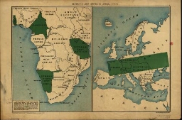
Germany's lost empire in Africa
Germany's lost empire in Africa
| Publisher | Stanford's Geog[raphical] Estab[lishmen]t |
| Publication Date | [1916?] |
-
A new chart of the Azores or Western Isles
A new chart of the Azores or Western Isles
| Statement of responsability | by W[illia]m Heather ; drawn revised and corrected by J[ohn] W[illiam] Norie, hydrographer |
| Publisher | [ John William Norie] |
| Publication Date | 1815 |
-
Plan of the Inlets of ferrol Coruña and Betanzos geometrically surveyed in 1787
Plan of the Inlets of ferrol Coruña and Betanzos geometrically surveyed in 1787
| Other title information | to the additional sketch intended to exhibit the position of the British Squadron, and the march of the troops from the Beach to the heights of Balon and Brion &c. with the situation of Spanish Squadron |
| Statement of responsability | by Don Vincent Tofiño de S. Miguel, Brigadier in the Spanish Naval Army ; published by W. Faden Geographer to His Majesty and to H R H the Prince of Wales |
| Publisher | W. Faden |
| Publication Date | January1st, 1801 |
-
Chart of Pulo Penang, now Prince of Walesªs island
Chart of Pulo Penang, now Prince of Walesªs island
| Statement of responsability | by A. Arrowsmith |
| Publication Date | 1805 |
-
The catholic Netherlands
The catholic Netherlands
| Other title information | comprehending 1. The dutchy of Brabant, divided into Austrian and Dutch Brabant, with the Austrian is United and Incorporated, the Margraviate of the Holy Roman Empire including the city of Antwerp and is territory. 2.The Lordship of Mecheln, to Austria. 3. The Dutchy of Limburg divided into Austrian and Dutch. 4. Gelderland, or Dutchy of Gelders divided into Austrian, Prussian and Dutch. 5. The Dutchy of Luxemburg, of with the French possess a smol share. 6. The County of Flanders belonging to da Austrian French and Dutch. 7. Namurois, or County of Namur to Austria, and small part to France. 8. County of Haynaut divided between France and Austria. 9. County of Artois and 10. Cambresis to France |
| Statement of responsability | Printed for Robert Sayer |
| Publisher | Robert Sayer |
| Publication Date | 1793 |
-
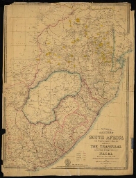
Eastern South Africa from the River Limpopo to Algoa Bay embracing de Transvaal Bechuana Land, and S...
Eastern South Africa from the River Limpopo to Algoa Bay embracing de Transvaal Bechuana Land, and S...
| Statement of responsability | by James Wyld, Geographer to the Queen |
| Publisher | James Wyld |
| Publication Date | 1889 |
-
Hindoostan
Hindoostan
| Statement of responsability | by J. Rennell ; engd. by J. Philips ; the writing by W. Harrisson |
| Publisher | J. Rennell, according to Act of Parliament |
| Publication Date | 1782 |
-
El Asia con toda la extension de sus reinos y provincias segun las ultimas y nuevas observationes de...
El Asia con toda la extension de sus reinos y provincias segun las ultimas y nuevas observationes de...
| Publisher | [s.n. |
| Publication Date | 17--] |
-
A military sketch of the country between Lisbon and Vimeiro occupied by the British Army under the c...
A military sketch of the country between Lisbon and Vimeiro occupied by the British Army under the c...
| Statement of responsability | Published with permission of the Quarter Master General by W. Faden Geographer to his Magestaty & to his Royal Highnefs the Prince of Wales |
| Publisher | W. Faden |
| Publication Date | 1810 |
-
Philipsª new map of Southern Africa, including the Cape Colony, Transvaal, and Natal
Philipsª new map of Southern Africa, including the Cape Colony, Transvaal, and Natal
| Statement of responsability | by Edwd[ard] Weller |
| Publisher | George Philip & Son |
| Publication Date | <[ca >1875] |
-
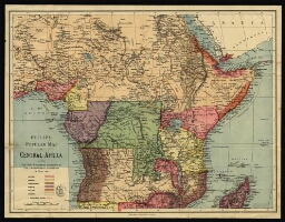
Philipsªpopular map of Central Africa showing the new boundaries according to the Anglo-German agree...
Philipsªpopular map of Central Africa showing the new boundaries according to the Anglo-German agree...
| Publisher | George Philip & Son |
| Publication Date | 1890 |
-
Spain & Portugal
Spain & Portugal
| Statement of responsability | drawn & engraved by J. Dower, Pentonville, London |
| Publisher | Henry Teesdale & Cº |
| Publication Date | 302 High Holborn, March 1834 |